Thursday, August 4, 2011

August 2: 1814 Finally Sees Light, and Whispers

By Michael English, Producer
(On the river near Wayson's Corner, Md.) -- At low tide here,  a white stripe dries pale and jagged on shoreline river brush, looking a little like it was painted on. For those who know, it tells the important tale of the last Patuxent high tide.  It's an easy code to break.  It simply remembers the most recent high water mark -- a convenient reminder of a never-ending cycle that drops the river nearly two feet in just a few hours.  Pay no attention, and you can find yourself high and dry on river mud, waiting.

In the afternoon, Videographer Marlene Rodman was busy composing shots of shoreline mud flats when Bob Neyland suddenly surfaced.  I could see he had something.  Marlene swung around to catch the shot.    Just then, someone switched off the lone dredge pump that was keeping sediment from re-blanketing the wreck's bow section. Now it was possible to capture audio as well, and Audio Engineer Gordon Masters extended his fish pole to catch it all.


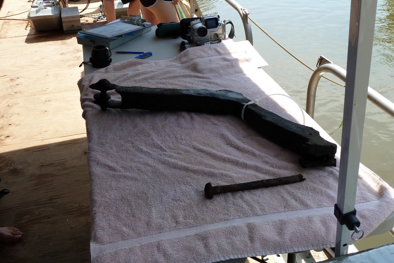
We'd been waiting for Neyland.  He'd been in the water for nearly an hour, accompanied by fellow Principal Investigator Julie Schablitsky.  We learned later they had worked carefully, methodically -- almost tediously -- in the murky water to free a part of the wreck that was loose and in danger of being swept away by the Patuxent's relentless current.  Now, Neyland floated it gently along the surface to the barge ladders, then passed it up.  It was brought aboard and immediately measured, drawn, cataloged and then re-immersed in riverwater to keep it from the open air.


Exactly what it is has yet to be determined, but Neyland believes it could be a Cathead -- a large piece of wood angled at 45 degrees that helps to hold a ship's anchor in place. But this wasn't an artifact from just any ship.  This ship could possibly be the USS Scorpion -- Joshua Barney's flagship during the War of 1812.  It was an exciting discovery -- the first identifiable piece of the ship itself that the crew and I had seen in our three days aboard the barge.  Busy as he was, Neyland gave us a good interview describing conditions below and the work it took to free the artifact from the wreck but, then -- like all of them -- so busy here at this site from morning until evening, he and the rest of his archeological team moved on to the next artifact to be cataloged, drawn or conserved.  This afternoon's discovery was special, yes, but there was more to be done and little time to do it.


But for us -- the uninitiated, witnessing history as it's made and getting caught up in it all -- it feels a little like a whisper from August 22, 1814, the last time our mystery ship sailed this winding channel and its brave sailors, with enemies nearby, kept a close eye on the tide line.

Wednesday, August 3, 2011

The Murky Patuxent Keeps Its Secrets Close


It's like swimming in a blizzard.  That's what local underwater cinematographer Nick Caloyianis said about his recent dive into the murky waters of the Patuxent River to capture HD video footage of the Scorpion  and its excavation site.

Caloyianis usually dives in water with considerably more clarity, and his underwater photographic subjects most of the time are sharks of the large and hungry variety.  Recently, he was photographing Great White sharks off the coast of New England for a television project.

But his interests in marine cinematography extend beyond sharks.  As a Maryland native, Caloyianis is an expert on life in the Chesapeake Bay -- something he's been shooting with a camera for decades.  He is a regular videographic contributor to Maryland Public Television nature documentary projects and produces segments for MPT's popular Outdoors Maryland series.

Last Friday, though, he donned his mask, flippers and airtank with one goal in mind: to record the excavation of the vessel that may be the USS Scorpion.  With dredge pumps pounding away on the barge topside, Caloyianis felt his way along the river bottom until he found the wreck.  With his state-of-the-art camera inside of a custom metal case, he spent about six hours in the water photographing the wreck.

As any of the divers on the Scorpion project will tell you, visibility at this site is all but impossible to predict.  Caloyianis reports that his dive, though successful, was marred by the severe thunderstorms that blew through a few days before.  Runoff from the downpour carried heavy sediment downriver to the excavation site.  The effect was, as Caloyianis and other divers attested, like swimming in a snowstorm.

Though the conditions were unfavorable, Caloyianis says he did get some clean video and still photos of the wreck -- some of which MPT viewers will be able to see when this documentary airs in 2012.

Sunday, July 10, 2011

8 July 2012: Meeting History -- and Making It -- on the Patuxent


 By Michael English, Producer
 (On location, somewhere on the Patuxent River) -- It's about as still and sticky as a Maryland July can be except for the occasional breeze that rustles tall marsh grass nearby.  I'm standing under welcomed shade provided by a pop-up canopy with Tim Pugh, MPT videographer, on a massive and frying-pan hot aluminum barge that's parked smack in the middle of a lazy bend on this historic and beautiful river.  Tim's Sony XD camera rests on his right shoulder as we wait for a Navy boat to pull alongside to off-load metal shoring.  I'm busy scribbling ideas in my notebook for shoots to come and taking in the visceral beauty of this place.


This part of the Patuxent isn't too wide -- maybe 100' at best.  The eastern bank is covered with lush, river-fed brush and a towering treeline that's deeply dug into a steep bank that rises 10' to 15'.  Looking west is a sparse grove of tall trees and underbrush near buoys that mark the outlines of what could be the wreck of the USS Scorpion.  The trees screen what lies beyond -- a vast marsh, crammed with lilypads, Cattails and bright green pockets of wild rice.   The horizon --  perhaps as far as a quarter mile back -- ends at the western shore.  Ospreys fly lazy circles, and we hear the cries of Red Tailed Hawks and Bluejays.


There's a dramatic history buried in this muddy river.  And there's history being made.  Maryland Public Television is capturing it all in Search for the Scorpion, a documentary that will be broadcast during the bicentennial of the War of 1812.

Archeologists believe that here, on August 22, 1814, a small number of Commodore Joshua Barney's sailors from his famed War of 1812 flotilla of 16 ships used charges to scuttle, or sink, the fleet.  They did so on direct orders from Barney, who was concerned the vessels might be captured by the British and used against Americans forces -- a common practice in those days.


Myth and legend about the flotilla's location is a common conversation in this part of southern Maryland -- something that locals have talked about for generations.  Some people say the fleet was sunk -- with much of the crew's belongings still on-board -- somewhere in the river near where I'm standing.  But the story also says that in the two centuries since, the wily Patuxent has shifted shape, bending and turning time and again -- and now the flotilla rests beneath a Wayson's Corner cornfield.


Those yarns were told, re-told and argued over until 1979, when two amateur archeologists from southern Maryland, Paleontologist Ralph Eshelman, and Author Don Shomette, found the very wreck lying under my feet.  In '79, Shomette and Eshelman dove the wreck, hoping that it was the USS Scorpion.  They excavated the site, gained access to the innards of the ship, and retrieved some intriguing artifacts from the wreck.  Included in the find was a surgeon's kit -- expensive and rare in those days. The thinking goes that such a find would indicate a flag vessel, since the fleet's medical officer would most likely be stationed on it.  Another artifact:  a tin grog cup was gently dug, uncovered and coaxed from the muck that's filled the ship's hold over two centuries.  The cup has the initials "C.W." scratched into it.  Shomette and Eshelman wondered whether it could possibly be Caesar Wentworth, an African American cook known to have been assigned to the Scorpion.


Now, archeologists are building on Shomette's and Eshelman's critical,  earlier work at the site, but this time the effort is better-funded and the investigators have the added benefit of using advanced technologies.  Over the next few weeks, they will use pumps to carefully vacuum sediment from around the wreck.  They estimate the ship -- which is about 60 feet long -- is buried in six to eight feet of sediment.  The bottom layer is clay, a material that has capped the ship in an airtight environment for two centuries.  That  helps to explain how the artifacts found in 1980 survived all of those years underwater.  Archeologists are hopeful the anaerobic nature of the ship's grave means that there are many more artifacts -- and history -- at the bottom of the river.


The buried mass of wood in the shape of a ship could very well be the USS Scorpion -- or it could be one of the flotilla's other vessels.  No one knows yet.  That's why the team will be here on the river for the next  five weeks or so -- to make history while they work to meet it face-to-face.

Check back for further updates on production of Search for the Scorpion.